|
|
The content of this page may not meet Wikimapia's policies,
this is unofficial storage source for any users purposes (upload images, make their pages, writing drafts for further project or documents, etc). You may read the official Wikimapia Documentation here. |
User Guide: Railroads edit
| |
|---|
| Getting started |
| Guidelines |
| Philosophy |
| Advice for new users |
| Editing places (tags) |
| Introduction Message |
| Adding place |
| Places and place tags |
| Languages |
| Polygons (outlines) |
| Photos |
| Addresses |
| Categories |
| Parent & Child tags |
| Comments |
| Deleting places |
| Deletion criteria |
| Linear features (Transportation) |
| Roads edit |
| Railroads edit |
| Ferry edit |
| Rivers edit |
| Other UI features |
| The main screen |
| Wikimapia's URL |
| Map types |
| My account (profile) |
| Geotools |
| Searching |
| User Script |
| Community |
| Forum |
| Finding help |
| Experience points |
| User account |
| User levels |
| Other users |
| Voting |
| Vandalism |
| Banning users |
| Miscellaneous |
| Miscellaneous |
| Technical issues |
| Satellite images |
| To do |
This article describes road editing in Wikimapia Beta. Road editing in Wikimapia Classic is no longer available. WikiMapia officially uses the term railroad to cover all other designations such as "railway lines", "train tracks" etc.
Railroads is a WikiMapia feature wherein you can mark out railway lines in WikiMapia. You can mark railroads by adding points. Once you anchor a point and move the cursor, a segment will automatically extend from it. A segment can only be established when another point is fixed to a location. These segments and points should be aligned accurately with the linear image of the railroad on the map.
The marking of railroads should follow the same principles as marking tags ie. the object/railroad to be marked must be visible and non-movable. Thus the marking of non-existent railroads or even non-visible railroads of historical importance should be avoided. If it isn't there don't mark it!
Contents |
Creating a Railroad
Firstly zoom into the map at zoom level 13 or more. You can check your browser address bar for "z=13" (or "z=14" or "z=15" or ... "z=20"), this indicates your zoom level. Note, however, that even though Wikimapia will allow you to draw roads at zoom 13, it would be preferential to zoom in further to get the best out of imparting points and segments for railroads more accurately.
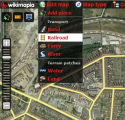
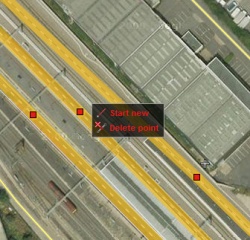
From the Wikimapia-BETA "Menu bar" along the top of the screen, select "Edit map" and then "Railroad" from the dropdown list (See Example 1). You will then enter "Railroad" mode. Click first where you want to start marking your railroad and then choose "Start new" option (See Example 2). By left-clicking your mouse you will have anchored a 'red dot' or point from which a light-yellow coloured segment shall issue forth and follow your cursor wherever you move it. You will then be able to set further points, joined by segments, by subsequent left-clicks of the mouse. This way you will be successfully laying linear markings along the desired railroad image on the map.
Once completed, click on the "Save" button in the bottom centre of the screen. Clicking on the "Cancel" button will erase all your work since your last save.
You can also create new railroads from others that are already marked. There are two ways in which you can do this. The first way is by clicking on an existing point along the railroad and then selecting the "Start new" option. If there is no existing railroad point where you want to start your new railroad, you can opt to click on the segment of the existing railroad and then choose the "Insert point" option via the context menu (See Example 3). You will then be able to continue creating railroads as described above.


