Canada /
British Columbia /
Hope /


The Hope Slide
World / Canada / British Columbia / Hope World / United States / Washington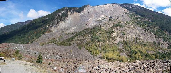
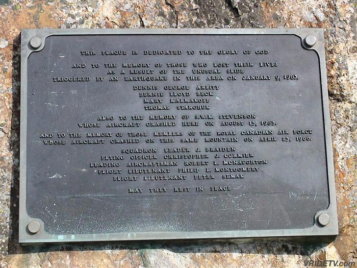
One of the largest landslides in Canadian history, occurring on January 9, 1965, killing four motorists.
The Hope Slide 46 million cubic meters of earth, rock and snow smashing down in a matter of seconds from the over 2000 meter high mountain it came from. Filling the bottom of the valley with 70 meters deep. Outram Lake at the foot of the mountain was completely buried sending the water and soft clay from the lake bed were shot violently up the mountain on the opposite side of the Valley.
www.travelthecanyon.com/hopeslide.html
mountain
Add category
Wikipedia article: http://en.wikipedia.org/wiki/Hope_Slide
Nearby cities:
Coordinates: 49°18'8"N 121°14'58"W
- Razorback 33 km
- Osprey Chain 93 km
- Tingle Peaks 96 km
- Orofino Mountain 108 km
- Mount Garibaldi Area 144 km
- Opal Cone Lava Flow 145 km
- Silver Star Ski Hill 198 km
- Mount Ida 204 km
- Mount Meager 226 km
- Black Dome Mountain 244 km
- Coquihalla Canyon Provincial Park 11 km
- Treasure Mountain Mine Project 14 km
- Hope, British Columbia 17 km
- Jones Lake Reservoir 28 km
- Chilliwack Lake Provincial Park 29 km
- E.C. Manning Provincial Park 31 km
- Chilliwack Lake 31 km
- Redoubt Glacier 39 km
- Ross Lake 51 km
- North Cascades National Park 76 km
Comments