Nandigama
India /
Andhra Pradesh /
Nandigama /
World
/ India
/ Andhra Pradesh
/ Nandigama
World / India / Andhra Pradesh / Krishna
town, municipality, mandal headquarter
Nandigama is a small town and a Mandal Headquarter(Mandal code-4)in Krishna District (District code-6), Andhra Pradesh, India. Total no. of villages under this mandal are 26.1 Pedavaram, 2 Thakkellapadu, 3 Latchapalem, 4 Munagacherla, 5 Nandigama (u)(p), 6 Magallu, 7 Konduru, 8 Ramireddipalle, 9 Jonnalagadda, 10 Konathamatmakuru, 11 Damuluru, 12 Thorra gudi padu, 13 Somavaram, 14 Rudravaram, 15 Gollamudi, 16 Pallagiri, 17 Satyavaram, 18 Raghava puram, 19 Ambarupeta, 20 Chandapuram, 21 Kurugantivari khandrika, 22 Lingalapadu, 23 Adivi ravulapadu, 24 Kethaveerunipadu, 25 Ithavaram, 26 Kanchela.
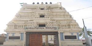
Nandigama is famous for the temples which had a great history for years. The mukkoti ekadasi is celebrated every year grandly in Nandigama.
This is a historical place with many places to see..Pallagirigattu,Sivalayam,Ramalayam,Raithupet. These places have historical importance,where Sri krishna devaraya had kept special interest in developing these places.Then the history of nandigama spreaded across the country...
Places in Nandigama.. 1.Gandhi Centre. 2.Pallagirigattu. 3.Temples. 4. Kanyaka parameswari Temple(Newly Built). 5.Muneru. 6.Red Hills.
Nearby cities:
Coordinates: 16°46'36"N 80°16'59"E
- Suryapet 87 km
- Kothagudem 96 km
- Balod 453 km
- Yavatmal 470 km
- Tiruvannamalai 519 km
- Hosur 522 km
- Dharmapuri District 564 km
- Mukkam Municipality 763 km
- Kodungallur 845 km
- Vapi 880 km
- Kongara Nagar 0.4 km
- Raithu Peta 1.4 km
- Pallagiri Hill 2.4 km
- Agri-gold layout 2.6 km
- Hanumantupalem 3 km
- Raghavapuram Hill 3.4 km
- Kanchala Near Keesara Vijayawada 8.1 km
- Thota Ravula Padu Cheruvu 10 km
- Cheruvu Kommu Palem 11 km
- Bobbillapadu lake 11 km
Comments